About the CoMSES Model Library more info
Our mission is to help computational modelers develop, document, and share their computational models in accordance with community standards and good open science and software engineering practices. Model authors can publish their model source code in the Computational Model Library with narrative documentation as well as metadata that supports open science and emerging norms that facilitate software citation, computational reproducibility / frictionless reuse, and interoperability. Model authors can also request private peer review of their computational models. Models that pass peer review receive a DOI once published.
All users of models published in the library must cite model authors when they use and benefit from their code.
Please check out our model publishing tutorial and feel free to contact us if you have any questions or concerns about publishing your model(s) in the Computational Model Library.
We also maintain a curated database of over 7500 publications of agent-based and individual based models with detailed metadata on availability of code and bibliometric information on the landscape of ABM/IBM publications that we welcome you to explore.
Displaying 10 of 1101 results for "Bin-Tzong Chi" clear search
Will you infect me with your opinion?
Jarosław Miszczak Krzysztof Domino | Published Tuesday, March 15, 2022 | Last modified Monday, August 29, 2022This model incorporates three mechanisms shaping the dynamics of opinion formation, which mimics the dynamics of the virus spreading in the population. There are three methods of getting infected (or convinced) - direct contact, indirect contact, and contact with ``contaminated’’ elements.
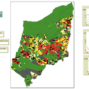
Multi-Agent Socio-Ecological Hani Terrace Model
Lei Dong Yunnan University | Published Saturday, March 29, 2025This model is to explore the changes of paddy field landscape and household livelihood structure in the village under different policy scenarios, evaluate the eco-social effects of different policies, and provide decision support tools for proposing effective and feasible policies.
Shared Norms and the Evolution of Ethnic Markers
Nathan Rollins | Published Friday, January 22, 2010 | Last modified Saturday, April 27, 2013The publication and mathematical model upon which this ABM is based shows one mechanism that can lead to stable behavioral and cultural traits between groups.
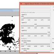
IDEAL
Arika Ligmann-Zielinska | Published Thursday, August 07, 2014IDEAL: Agent-Based Model of Residential Land Use Change where the choice of new residential development in based on the Ideal-point decision rule.
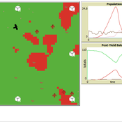
Peer reviewed Avian pest control: Yield outcome due to insectivorous birds, falconry, and integration of nest boxes.
David Jung | Published Monday, November 13, 2023 | Last modified Sunday, November 19, 2023The model aims to simulate predator-prey relationships in an agricultural setting. The focus lies on avian communities and their effect on different pest organisms (here: pest birds, rodents, and arthropod pests). Since most case studies focused on the impact on arthropod pests (AP) alone, this model attempts to include effects on yield outcome. By incorporating three treatments with different factor levels (insectivorous bird species, falconry, nest box density) an experimental setup is given that allows for further statistical analysis to identify an optimal combination of the treatments.
In light of a global decline of birds, insects, and many other groups of organisms, alternative practices of pest management are heavily needed to reduce the input of pesticides. Avian pest control therefore poses an opportunity to bridge the disconnect between humans and nature by realizing ecosystem services and emphasizing sustainable social ecological systems.
Agent-based Simulation of Innovation Diffusion
Theresa Elbracht | Published Monday, May 19, 2025The agent-based simulation of innovation diffusion is based on the idea of the Bass model (1969).
The adoption of an agent is driven two parameters: its innovativess p and its prospensity to conform with others. The model is designed for a computational experiment building up on the following four model variations:
(i) the agent population it fully connected and all agents share the same parameter values for p and q
(ii) the agent population it fully connected and agents are heterogeneous, i.e. individual parameter values are drawn from a normal distribution
(iii) the agents population is embeded in a social network and all agents share the same parameter values for p and q
…
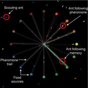
Composite Collective Decision Making - ant colony foraging model
Tomer Czaczkes Benjamin I Czaczkes | Published Thursday, December 17, 2015The model explores how two types of information - social (in the form of pheromone trails) and private (in the form of route memories) affect ant colony level foraging in a variable enviroment.
Informal risk-sharing cooperatives : ORP and Learning
Juliette Rouchier Victorien Barbet Renaud Bourlès | Published Monday, February 13, 2017 | Last modified Tuesday, May 16, 2023The model studies the dynamics of risk-sharing cooperatives among heterogeneous farmers. Based on their knowledge on their risk exposure and the performance of the cooperative farmers choose whether or not to remain in the risk-sharing agreement.
Peer reviewed Price Evolution with Expectations
J M Applegate Gesine Steudel Armin Haas Carlo Jaeger | Published Friday, September 10, 2021The Price Evolution with Expectations model provides the opportunity to explore the question of non-equilibrium market dynamics, and how and under which conditions an economic system converges to the classically defined economic equilibrium. To accomplish this, we bring together two points of view of the economy; the classical perspective of general equilibrium theory and an evolutionary perspective, in which the current development of the economic system determines the possibilities for further evolution.
The Price Evolution with Expectations model consists of a representative firm producing no profit but producing a single good, which we call sugar, and a representative household which provides labour to the firm and purchases sugar.The model explores the evolutionary dynamics whereby the firm does not initially know the household demand but eventually this demand and thus the correct price for sugar given the household’s optimal labour.
The model can be run in one of two ways; the first does not include money and the second uses money such that the firm and/or the household have an endowment that can be spent or saved. In either case, the household has preferences for leisure and consumption and a demand function relating sugar and price, and the firm has a production function and learns the household demand over a set number of time steps using either an endogenous or exogenous learning algorithm. The resulting equilibria, or fixed points of the system, may or may not match the classical economic equilibrium.
Landscape connectivity and predator–prey population dynamics
Jacopo A. Baggio | Published Thursday, November 10, 2011 | Last modified Saturday, April 27, 2013A simple model to assess the effect of connectivity on interacting species (i.e. predator-prey type)
Displaying 10 of 1101 results for "Bin-Tzong Chi" clear search
