Our mission is to help computational modelers develop, document, and share their computational models in accordance with community standards and good open science and software engineering practices. Model authors can publish their model source code in the Computational Model Library with narrative documentation as well as metadata that supports open science and emerging norms that facilitate software citation, computational reproducibility / frictionless reuse, and interoperability. Model authors can also request private peer review of their computational models. Models that pass peer review receive a DOI once published.
All users of models published in the library must cite model authors when they use and benefit from their code.
Please check out our model publishing tutorial and feel free to contact us if you have any questions or concerns about publishing your model(s) in the Computational Model Library.
Displaying 10 of 186 results for "Wil Hennen" clear search
ADAM: Agent-based Demand and Assignment Model
D Levinson | Published Monday, August 29, 2011 | Last modified Saturday, April 27, 2013The core algorithm is an agent-based model, which simulates travel patterns on a network based on microscopic decision-making by each traveler.
Telephone Game
Julia Kasmire | Published Friday, January 10, 2020This is a model of a game of Telephone (also known as Chinese Whishpers in the UK), with agents representing people that can be asked, to play. The first player selects a word from their internal vocabulary and “whispers” it to the next player, who may mishear it depending on the current noise level, who whispers that word to the next player, and so on.
When the game ends, the word chosen by the first player is compared to the word heard by the last player. If they match exactly, all players earn large prize. If the words do not match exactly, a small prize is awarded to all players for each part of the words that do match. Players change color to reflect their current prize-count. A histogram shows the distribution of colors over all the players.
The user can decide on factors like
* how many players there are,
…
Agent-based Simulation of Time Management
Hang Xiong | Published Thursday, March 24, 2016 | Last modified Friday, March 25, 2016This model simulates how the strategy one manages time affect the well-being that he/she can obtain.
Shellmound Trade
Henrique de Sena Kozlowski | Published Saturday, June 15, 2024This model simulates different trade dynamics in shellmound (sambaqui) builder communities in coastal Southern Brazil. It features two simulation scenarios, one in which every site is the same and another one testing different rates of cooperation. The purpose of the model is to analyze the networks created by the trade dynamics and explore the different ways in which sambaqui communities were articulated in the past.
How it Works?
There are a few rules operating in this model. In either mode of simulation, each tick the agents will produce an amount of resources based on the suitability of the patches inside their occupation-radius, after that the procedures depend on the trade dynamic selected. For BRN? the agents will then repay their owed resources, update their reputation value and then trade again if they need to. For GRN? the agents will just trade with a connected agent if they need to. After that the agents will then consume a random amount of resources that they own and based on that they will grow (split) into a new site or be removed from the simulation. The simulation runs for 1000 ticks. Each patch correspond to a 300x300m square of land in the southern coast of Santa Catarina State in Brazil. Each agent represents a shellmound (sambaqui) builder community. The data for the world were made from a SRTM raster image (1 arc-second) in ArcMap. The sites can be exported into a shapefile (.shp) vector to display in ArcMap. It uses a UTM Sirgas 2000 22S projection system.
Evolution of cooperation with strangers
Marco Janssen | Published Friday, October 15, 2010 | Last modified Wednesday, November 13, 2013The model is used to study the conditions under which agents will cooperate in one-shot two-player Prisoner’s Dilemma games if they are able to withdraw from playing the game and can learn to recogniz
Adaptive model of a consumer advice network
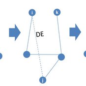
Peng Shao | Published Monday, May 14, 2018In the consumer advice network, users with connections can interact with each other, and the network topology will change during the opinion interaction. When the opinion distance from i to j is greater than the confidence threshold, the two consumers cannot exchange opinions, and the link between them will disconnect with probability DE. Then, a link from node i to node k is established with probability CE and node i learning opinion from node k.
PopComp
Andre Costopoulos | Published Thursday, December 10, 2020PopComp by Andre Costopoulos 2020
andre.costopoulos@ualberta.ca
Licence: DWYWWI (Do whatever you want with it)
I use Netlogo to build a simple environmental change and population expansion and diffusion model. Patches have a carrying capacity and can host two kinds of populations (APop and BPop). Each time step, the carrying capacity of each patch has a given probability of increasing or decreasing up to a maximum proportion.
…
Peer reviewed ABM for Social Cohesion and Wellbeing(ABMSCWB)
Taseer Salahuddin Hasan Vergil | Published Wednesday, June 25, 2025ABM model studying impact of social cohesion on wellbeing of a society. Ibn Khaldun’s cyclical theory of history is being used as the theoretical lens along with some other theories. Social cohesion is measured as TSC = (TVE + 2 * (TPI * TPL - TNI * TNL))/((TPI+TNI))
Where
TSC total-social-cohesion ; Variable for social cohesion
TPI total-positive-interactions ; Count of positive interactions
TNI total-negative-interactions ; Count of negative interactions
TPL total-positive-learning ; Count of positive learning outcomes
…

Diet breadth model from Optimal Foraging Theory (Human Behavioral Ecology)
C Michael Barton | Published Wednesday, November 26, 2008 | Last modified Thursday, March 12, 2015Diet breadth is a classic optimal foraging theory (OFT) model from human behavioral ecology (HBE). Different resources, ranked according to their food value and processing costs, are distributed in th
Forest Logging and Ecosystem Degradation
Carla Guerrero | Published Sunday, February 15, 2026This model simulates a forest ecosystem affected by human logging. We explore different kind of approaches and their possible consequences for the ecosystem. Loggers can either be responsible or irresponsible, they will either take care to cut trees or not. In turn their actions will have consequences on the quality of the soil, the atmosphere as well as their profit made from logging. In this model we see that even careful management cannot prevent the degradation of the forest ecosystem.
Displaying 10 of 186 results for "Wil Hennen" clear search