Our mission is to help computational modelers develop, document, and share their computational models in accordance with community standards and good open science and software engineering practices. Model authors can publish their model source code in the Computational Model Library with narrative documentation as well as metadata that supports open science and emerging norms that facilitate software citation, computational reproducibility / frictionless reuse, and interoperability. Model authors can also request private peer review of their computational models. Models that pass peer review receive a DOI once published.
All users of models published in the library must cite model authors when they use and benefit from their code.
Please check out our model publishing tutorial and feel free to contact us if you have any questions or concerns about publishing your model(s) in the Computational Model Library.
Displaying 10 of 814 results NetLogo clear search
Peer reviewed Charging behaviour of electric vehicle drivers
Wilfried van Sark Annemijn Peters Floor Alkemade Mart van der Kam | Published Wednesday, May 08, 2019 | Last modified Tuesday, April 14, 2020This model was developed to study the combination of electric vehicles (EVs) and intermitten renewable energy sources. The model presents an EV fleet in a fictional area, divided into a residential area, an office area and commercial area. The area has renewable energy sources: wind and PV solar panels. The agents can be encouraged to charge their electric vehicles at times of renewable energy surplus by introducing different policy interventions. Other interesting variables in the model are the installed renewable energy sources, EV fleet composition and available charging infrastructure. Where possible, use emperical data as input for our model. We expand upon previous models by incorporating environmental self-identity and range anxiety as agent variables.
A Simulation of Arab Spring Protests Informed by Qualitative Evidence
Bruce Edmonds Stephanie Dornschneider | Published Monday, April 29, 2019 | Last modified Friday, May 24, 2019The purpose of the simulation was to explore and better understand the process of bridging between an analysis of qualitative data and the specification of a simulation. This may be developed for more serious processes later but at the moment it is merely an illustration.
This exercise was done by Stephanie Dornschneider (School of Politics and International Relations, University College Dublin) and Bruce Edmonds to inform the discussion at the Lorentz workshop on “Integrating Qualitative and Quantitative Data using Social Simulation” at Leiden in April 2019. The qualitative data was collected and analysed by SD. The model specification was developed as the result of discussion by BE & SD. The model was programmed by BE. This is described in a paper submitted to Social Simulation 2019 and (to some extent) in the slides presented at the workshop.
BENCHv.2 model
Leila Niamir | Published Sunday, April 28, 2019The BENCH agent-based model is designed and developed to study shifts in residential energy use and corresponding emissions driven by behavioral changes among heterogeneous individuals.
WOLVES - simulating wolf reappearance in the Netherlands
Kim van Vliet Zoë Delamore | Published Saturday, April 27, 2019This is an agent-based model, simulating wolf (Canis Lupus) reappearance in the Netherlands. The model’s purpose is to allow researchers to investigate the reappearance of wolves in the Netherlands and the possible effect of human interference. Wolf behaviour is modelled according to the literature. The suitability of the Dutch landscape for wolf settlement has been determined by Lelieveld (2012) [1] and is transformed into a colour-coded map of the Netherlands. The colour-coding is the main determinant of wolf settlement. Human involvement is modelled through the public opinion, which varies according to the size, composition and behaviour of the wolf population.
[1] Lelieveld, G.: Room for wolf comeback in the Netherlands, (2012).
Model for decision making of farmers to vaccinate against blue tongue virus
Egil Fischer | Published Wednesday, April 24, 2019This model combines decision making models of individual farmers with a model of the spatial spread between farms of blue tongue virus.
Peer reviewed lgm_ecodynamics
Colin Wren | Published Monday, April 22, 2019This is a modification of a model published previous by Barton and Riel-Salvatore (2012). In this model, we simulate six regional populations within Last Glacial Maximum western Europe. Agents interact through reproduction and genetic markers attached to each of six regions mix through subsequent generations as a way to track population dynamics, mobility, and gene flow. In addition, the landscape is heterogeneous and affects agent mobility and, under certain scenarios, their odds of survival.
Mission San Diego Model
Carolyn Orbann | Published Monday, April 15, 2019The Mission San Diego model is an epidemiological model designed to test hypotheses related to the spread of the 1805-1806 measles epidemic among indigenous residents of Mission San Diego during the early mission period in Alta California. The model community is based on the population of the Mission San Diego community, as listed in the parish documents (baptismal, marriage, and death records). Model agents are placed on a map-like grid that consists of houses, the mission church, a women’s dormitory (monjeria) adjacent to the church, a communal kitchen, priest’s quarters, and agricultural fields. They engage in daily activities that reflect known ethnographic patterns of behavior at the mission. A pathogen is introduced into the community and then it spreads throughout the population as a consequence of individual agent movements and interactions.
St Anthony flu
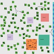
Lisa Sattenspiel | Published Monday, April 15, 2019The St Anthony flu model is an epidemiological model designed to test hypotheses related to the spread of the 1918 influenza pandemic among residents of a small fishing community in Newfoundland and Labrador. The 1921 census data from Newfoundland and Labrador are used to ensure a realistic model population; the community of St. Anthony, NL, located on the tip of the Northern Peninsula of the island of Newfoundland is the specific population modeled. Model agents are placed on a map-like grid that consists of houses, two churches, a school, an orphanage, a hospital, and several boats. They engage in daily activities that reflect known ethnographic patterns of behavior in St. Anthony and other similar communities. A pathogen is introduced into the community and then it spreads throughout the population as a consequence of individual agent movements and interactions.
Peer reviewed Collectivities
Nigel Gilbert | Published Tuesday, April 09, 2019 | Last modified Thursday, August 22, 2019The model that simulates the dynamic creation and maintenance of knowledge-based formations such as communities of scientists, fashion movements, and subcultures. The model’s environment is a spatial one, representing not geographical space, but a “knowledge space” in which each point is a different collection of knowledge elements. Agents moving through this space represent people’s differing and changing knowledge and beliefs. The agents have only very simple behaviors: If they are “lonely,” that is, far from a local concentration of agents, they move toward the crowd; if they are crowded, they move away.
Running the model shows that the initial uniform random distribution of agents separates into “clumps,” in which some agents are central and others are distributed around them. The central agents are crowded, and so move. In doing so, they shift the centroid of the clump slightly and may make other agents either crowded or lonely, and they too will move. Thus, the clump of agents, although remaining together for long durations (as measured in time steps), drifts across the view. Lonely agents move toward the clump, sometimes joining it and sometimes continuing to trail behind it. The clumps never merge.
The model is written in NetLogo (v6). It is used as a demonstration of agent-based modelling in Gilbert, N. (2008) Agent-Based Models (Quantitative Applications in the Social Sciences). Sage Publications, Inc. and described in detail in Gilbert, N. (2007) “A generic model of collectivities,” Cybernetics and Systems. European Meeting on Cybernetic Science and Systems Research, 38(7), pp. 695–706.
Stylized Spatial-Social Subsystem based on Luhmann's theory (S4Luhmann)
Marcos Aurélio Santos da Silva | Published Saturday, April 06, 2019The model proposes a translation of some Luhmann’s concepts (social sub-system, perturbation, dissipation, social communication and power) into a model using a stylized spatial-society as a metaphor of a Luhmann’s social subsystem. The model has been used to improve the social theory understanding and to evaluate the effect of different parameterization in the global stabilization and individual/social power distribution.
Displaying 10 of 814 results NetLogo clear search