Our mission is to help computational modelers develop, document, and share their computational models in accordance with community standards and good open science and software engineering practices. Model authors can publish their model source code in the Computational Model Library with narrative documentation as well as metadata that supports open science and emerging norms that facilitate software citation, computational reproducibility / frictionless reuse, and interoperability. Model authors can also request private peer review of their computational models. Models that pass peer review receive a DOI once published.
All users of models published in the library must cite model authors when they use and benefit from their code.
Please check out our model publishing tutorial and feel free to contact us if you have any questions or concerns about publishing your model(s) in the Computational Model Library.
Displaying 10 of 214 results for "Marc Choisy" clear search
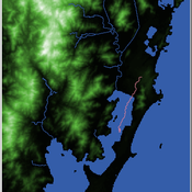
Shellmound Mobility
Henrique de Sena Kozlowski | Published Saturday, June 15, 2024Least Cost Path (LCP) analysis is a recurrent theme in spatial archaeology. Based on a cost of movement image, the user can interpret how difficult it is to travel around in a landscape. This kind of analysis frequently uses GIS tools to assess different landscapes. This model incorporates some aspects of the LCP analysis based on GIS with the capabilities of agent-based modeling, such as the possibility to simulate random behavior when moving. In this model the agent will travel around the coastal landscape of Southern Brazil, assessing its path based on the different cost of travel through the patches. The agents represent shellmound builders (sambaquieiros), who will travel mainly through the use of canoes around the lagoons.
How it works?
When the simulation starts the hiker agent moves around the world, a representation of the lagoon landscape of the Santa Catarina state in Southern Brazil. The agent movement is based on the travel cost of each patch. This travel cost is taken from a cost surface raster created in ArcMap to represent the different cost of movement around the landscape. Each tick the agent will have a chance to select the best possible patch to move in its Field of View (FOV) that will take it towards its target destination. If it doesn’t select the best possible patch, it will randomly choose one of the patches to move in its FOV. The simulation stops when the hiker agent reaches the target destination. The elevation raster file and the cost surface map are based on a 1 Arc-second (30m) resolution SRTM image, scaled down 5 times. Each patch represents a square of 150m, with an area of 0,0225km². The dataset uses a UTM Sirgas 2000 22S projection system. There are four different cost functions available to use. They change the cost surface used by the hikers to navigate around the world.
A simulation model for Dublin city
umesh7lowe | Published Friday, April 10, 2026An agent-based model of urban travel behaviour in Dublin, Ireland, built in NetLogo and empirically grounded in 2016 travel survey data. Each agent represents a Dublin resident initialised with real socio-demographic attributes — including age, gender, household size and car ownership, income, driving licence status, and access to local amenities — alongside observed trip characteristics such as distance, travel time, and trip type (work, shopping, leisure).
At each time step, agents choose between four transport modes (car, public transport, cycling, and walking) across short, medium, and long trips. Mode choice is governed by a preference vector that weighs personal need satisfaction against social influence from neighbouring agents reflecting consumat framework. Satisfaction evolves dynamically based on cost (incorporating Irish motor tax bands and per-km operating rates), travel time, and trip-type suitability, with an uncertainty parameter capturing variability in perceived utility over time.
The model tracks aggregate modal shares and total CO2 emission at each tick, enabling exploration of how policy interventions — such as fuel taxation, public transport pricing, or active travel incentives — might shift the city’s travel demand profile over 100 simulated days.
Peer reviewed Garbage can model Excel reconstruction
Smarzhevskiy Ivan | Published Tuesday, August 19, 2014 | Last modified Tuesday, July 30, 2019Reconstruction of the original code M. Cohen, J. March, and J. Olsen garbage can model, realized by means of Microsoft Office Excel 2010
Growing Unpopular Norms. A Network-Situated ABM of Norm Choice.
C Merdes | Published Tuesday, November 22, 2016 | Last modified Saturday, March 17, 2018The model’s purpose is to provide a potential explanation for the emergence, sustenance and decline of unpopular norms based on pluralistic ignorance on a social network.
Patch choice model from Optimal Foraging Theory (Human Behavioral Ecology)
C Michael Barton | Published Saturday, November 22, 2008 | Last modified Saturday, April 27, 2013NetLogo model of patch choice model from optimal foraging theory (human behavioral ecology).
Dynamics of Public Opinion with Diverse Media and Audiences' Choice
Zhongtian Chen | Published Sunday, April 25, 2021Studies on the fundamental role of diverse media in the evolution of public opinion can protect us from the spreading brainwashing, extremism, and terrorism. Many fear the information cocoon may result in polarization of the public opinion. The model of opinion dynamics that considers different influences and horizons for every individual, and the simulations are based on a real-world social network.
A model of urban expansion policy scenarios using an agent-based approach—a case of the Guangzhou Metropolitan Region of China
Guangjin Tian | Published Friday, March 21, 2014Three policy scenarios for urban expansion under the influences of the behaviours and decision modes of four agents and their interactions have been applied to predict the future development patterns of the Guangzhou metropolitan region.
Lifestyle tradeoffs and the decline of well-being
Chris Thron | Published Friday, January 01, 2016Scilab version of an agent-based model of societal well-being, based on the factors of: overvaluation of conspicuous prosperity; tradeoff rate between inconspicuous/conspicuous well-being factors; turnover probability; and individual variation.
Modeling The Transition to Public School Choice (Model II from paper)
Spiro Maroulis Eytan Bakshy Louis Gomez Uri Wilensky | Published Friday, March 22, 2013 | Last modified Tuesday, August 27, 2013This is an agent-based model that captures the dynamic processes related to moving from an educational system where the school a student attends is based on assignment to a neighborhood school, to one that gives households more choice among existing and newly formed public schools.
Team Problem Solving and Motivation under Disorganization
Dinuka Herath | Published Sunday, August 13, 2017The model combines the two elements of disorganization and motivation to explore their impact on teams. Effects of disorganization on team task performance (problem solving)
Displaying 10 of 214 results for "Marc Choisy" clear search